CLA ///
CLA's branded drone and mountain artwork
AERIAL INTELLIGENCE / UNITED STATES

PRECISION
FROM ABOVE.

Aerial LiDAR, advanced mapping, 3D scanning and technical inspection support for the sites that matter.

+YOUR ACTUAL BRAND ARTWORK
NEXT.JS SOURCE HAS PHOTO-INFORMED M400 MODEL
AERIAL MAPPING ✦ 3D SCANNING ✦ THERMOGRAPHY ✦ SITE VERIFICATION ✦ DIGITAL AS-BUILTS ✦ AERIAL MAPPING ✦ 3D SCANNING ✦ THERMOGRAPHY ✦ SITE VERIFICATION ✦ DIGITAL AS-BUILTS ✦
01 / OUR PURPOSEGEOSPATIAL DATA / FIELD REALITY
WE GO BEYOND PHOTOGRAPHY.

DATA THAT
GOES DEEPER.

Every project starts with a real site—and a question that needs a defensible answer. CLA helps engineering, construction, survey and asset teams document existing conditions and see the site from a different perspective.

ACQUIREPROCESSCOMMUNICATE
01 / CAPTURE02 / CONVERT03 / INTERPRET04 / DELIVER
02 / LIDAR SURVEY VISUALIZATIONINTERACTIVE / INTERNAL REVIEW ONLY
MURPHYS CREEK / SURVEY DATA

SCAN INTO
REAL TERRAIN.

Explore a point-cloud style visualization and actual CAD terrain contours derived from the Murphys Creek survey. Drag to orbit or use the slider to reveal the data.

MURPHYS CREEK / LIDAR SURVEY VISUALINTERNAL / NOT SURVEY GRADE
◉ LIDAR-DERIVED / POINT CLOUD VISUALIZATION
DRAG / ORBITWHEEL / ZOOMPOINT CLOUD VIEW / CAD CONTOUR VIEW
03 / WHAT WE DOFIELD CAPTURE TO DIGITAL DELIVERABLES
OUR CAPABILITIES

EVERY ANGLE.
MORE CONTEXT.

Multiple acquisition tools. One objective: give project teams better information about their sites and assets.

AERIAL + HANDHELD / PROFESSIONAL THERMOGRAPHY

INSIGHT BEYOND
VISIBLE LIGHT.

Aerial and handheld thermographic inspection services delivered by an ITC Level I / Category I Certified Thermographer, supporting condition assessment, anomaly identification, and documentation.

FAA PART 107 REMOTE PILOTITC LEVEL I / CATEGORY I CERTIFIED THERMOGRAPHER
DISCUSS A THERMOGRAPHY PROJECT ↗
Infrared Training Center Level I / Category I Certified Infrared Thermographer seal with numeric details obscured
SUPPORTING CREDENTIAL / NUMERIC DETAILS REDACTED FOR WEB DISPLAY
04 / FLIGHT FEASIBILITYFAA FACILITY MAP / PRELIMINARY SITE SCREEN
BEFORE THE DRONE LEAVES THE GROUND

CAN WE
FLY YOUR SITE?

Choose your proposed project location. Review the FAA’s published UAS Facility Map value where available, and request CLA’s proper feasibility review.

LOCATION INTELLIGENCE U.S. / PRE-FLIGHT
LOADING INTERACTIVE MAP…
CLICK MAP TO SELECT A SITEMAP DATA © OPENSTREETMAP
01 / IDENTIFY THE SITEU.S. ADDRESS OR PIN

Uses the U.S. Census street-address geocoder. For remote sites, use a map pin or coordinates.

SELECTED SITENo site selected

Select a site; FAA grid information is not flight authorization.

02 / AIRSPACE PLANNING RESULT

SELECT A LOCATION TO BEGIN.

This preliminary screen reviews one FAA map dataset. It does not assess every restriction or grant flight permission.

NEXT STEP / CLA PROJECT REVIEW

CLA can review site access, acquisition methods, airspace authorization requirements, and scheduling considerations.

IMPORTANT: FAA UAS Facility Map values support possible authorization requests and do not authorize flight. This tool does not check airspace classification outside published grids, TFRs, NOTAMs, stadium/security restrictions, special-use areas, local rules, weather or flight conditions.

FAA FACILITY MAPS ↗FAA / LAANC ↗CHECK TFRs ↗

Privacy: Address lookup uses the U.S. Census Bureau; FAA checks send selected coordinates to an FAA-hosted public dataset. Maps use OpenStreetMap tiles. No site is submitted or saved by this HTML prototype. This preview requires network access for live lookups and may be limited by cross-origin restrictions; the Next.js edition proxies requests securely on its server.

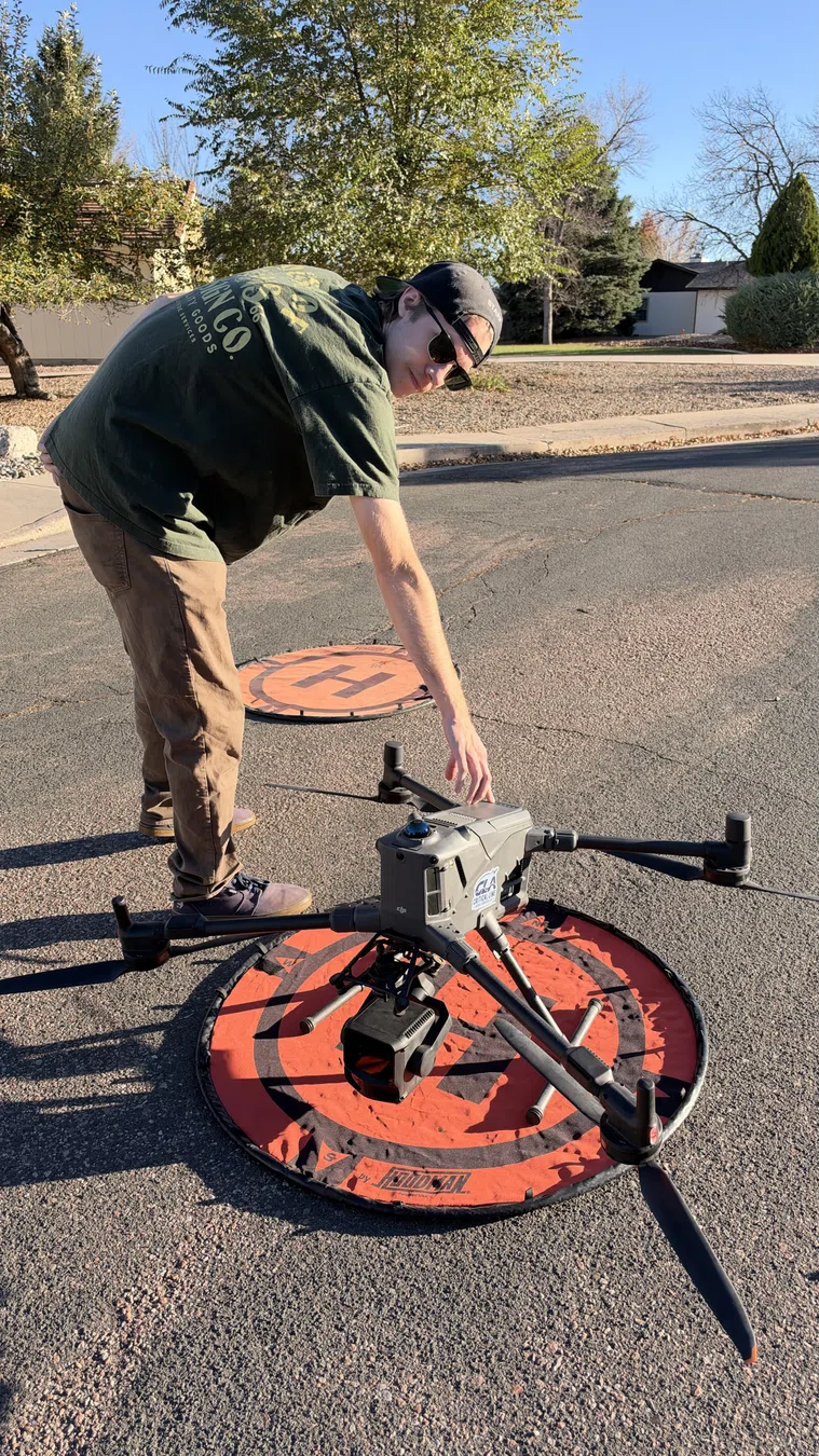
Drone being prepared on field landing pad
ACTUAL CLA FIELD PHOTOGRAPHY

BUILT IN
THE FIELD.

Behind the 3D visualization is the preparation, control and collection work that makes the data possible.

EXPLORE PROJECT ARCHIVE ↗
FIELD LOG / 001
FIELD JOURNAL / AUTHENTIC IMAGERYPHOTO + VIDEO / 001—006
BEHIND THE DATA

THE FIELD
IS THE PROOF.

Actual imagery from field operations, equipment and varied terrain. Explore the collection to see the on-site work behind the digital deliverables.

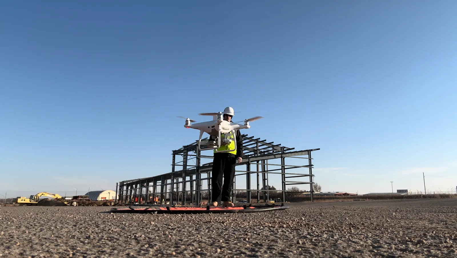
Drone at construction site
ORIGINAL FIELD MEDIA 01 / 06
OPERATIONS / 01CLA / FIELD LOG

Aircraft & site setup

Industrial-site field photograph showing aircraft preparation.

01 / 06

Internal preview. Field photos are not assigned to a named project or client until attribution and publication permissions are confirmed.

04 / SELECTED DATASETSELECTRICAL / COMMERCIAL / LAND
PROJECT ARCHIVE / INTERNAL PREVIEW

PROOF IN
THE OUTPUT.

Real survey data sources across electrical, commercial and land-development work. Four images are from processing reports.

Murphys Creek report orthoACTUAL REPORT PREVIEW
01 / ELECTRICAL INFRASTRUCTURE2025

Murphys Creek

LiDAR point cloud / orthophoto / terrain model

Gilcrest report orthoACTUAL REPORT PREVIEW
02 / ELECTRICAL INFRASTRUCTURE2025

Gilcrest

LiDAR point cloud / orthophoto / terrain model

Pawnee report orthoACTUAL REPORT PREVIEW
03 / ELECTRICAL INFRASTRUCTURE2026

Pawnee

LiDAR point cloud / orthophoto / terrain model

QuickTrip report orthoACTUAL REPORT PREVIEW
04 / COMMERCIAL SITE2026

QuickTrip 4298

Site orthophoto / LiDAR point cloud / contours

Real source-derived Timber Ridge F13 CAD contour vertex sampleACTUAL CAD CONTOUR SAMPLE
05 / LAND DEVELOPMENT2026

Timber Ridge F13

Point cloud / terrain model / contours

MORE REAL PROJECT DATA / FOUR NEW ARCHIVES

BEYOND
THE SUBSTATION.

Different terrain. Different industries. The same need to see existing conditions clearly. Explore each actual survey orthophoto alongside CAD geometry from its corresponding project folder.

Original Drake TNGG Plant orthophoto export
ACTUAL SITE ORTHOPHOTO
ARCHIVE FILES // 2023TRUE AERIAL IMAGERY
06 / SURVEY ARCHIVE2023
Industrial facility

Drake TNGG Plant

An industrial site, mapped from above.

Source archive includes an aerial orthophoto, point-cloud exports, digital terrain and surface models, and 3D CAD geometry.

DOCUMENTED SOURCE FILESOrthophoto / point cloud / terrain and surface models / CAD
Original JPEG orthophoto exportDISCUSS SIMILAR WORK
Original Rocky Mountain Rail Park orthophoto export
ACTUAL SITE ORTHOPHOTO
ARCHIVE FILES // 2022TRUE AERIAL IMAGERY
07 / SURVEY ARCHIVE2022
Transportation / industrial land

Rocky Mountain Rail Park

Large-site context for planning teams.

The archive contains site orthophotography, a point-cloud dataset, terrain products, and a triangulated CAD surface.

DOCUMENTED SOURCE FILESOrthophoto / point cloud / terrain models / CAD surface
Original JPEG orthophoto exportDISCUSS SIMILAR WORK
Original Costa Rica Prop 1 orthophoto export
ACTUAL SITE ORTHOPHOTO
ARCHIVE FILES // 2021TRUE AERIAL IMAGERY
08 / SURVEY ARCHIVE2021
Land / terrain archive

Costa Rica Prop 1

Topography that reads beyond a photograph.

The supplied dataset includes natural-terrain aerial imagery, point-cloud export, digital terrain and surface models, and CAD surface geometry.

DOCUMENTED SOURCE FILESOrthophoto / point cloud / DSM and DTM / CAD surface
Original JPEG orthophoto exportDISCUSS SIMILAR WORK
Original HERC Copper Mountain orthophoto export
ACTUAL SITE ORTHOPHOTO
ARCHIVE FILES // 2020TRUE AERIAL IMAGERY
09 / SURVEY ARCHIVE2020
Mountain corridor / terrain

HERC Copper Mountain

Complex ground, precisely documented.

An elongated mountain-site acquisition archive with a true orthophoto, exported point-cloud data, and triangulated surface models.

DOCUMENTED SOURCE FILESOrthophoto / point cloud / 3D surface model
Original JPEG orthophoto exportDISCUSS SIMILAR WORK

INTERNAL PORTFOLIO REVIEW: These are genuine user-supplied survey archives. CLA confirms it holds rights to the supplied survey materials. Review infrastructure sensitivity and project descriptions before public launch. Image and CAD views are reduced, illustrative web presentations and are not engineering deliverables.

FIVE MORE SURVEYS / CIVIL + TRANSPORTATION

FOLLOW
THE ALIGNMENT.

From individual land-development sites to multi-flight highway corridors. Explore the original orthophotos and corresponding CAD data from the source archives.

Actual source survey visualization from E-470 & Sable
ACTUAL SURVEY DATA
DXF CONTOURS / REAL ELEVATION VERTICES
WEB PREVIEW / NOT FOR DESIGN OR MEASUREMENT
10 / SURVEY ARCHIVE2025
Transportation corridor

E-470 & Sable

Existing conditions at a transportation interface.

This survey archive includes an aerial orthophoto, LiDAR point-cloud export, digital terrain model, CAD contours and a processing report. The website image is sourced from the actual CAD contour file because the full orthophoto is not yet web-ready.

DOCUMENTED SURVEY EXPORTSOrthophoto / point cloud / DTM / CAD contours
SOURCE-DERIVED DATA VIEWSDISCUSS A SURVEY
Actual source survey visualization from Meadows Filing 19
ACTUAL SURVEY DATA
ACTUAL ORTHOPHOTO
WEB PREVIEW / NOT FOR DESIGN OR MEASUREMENT
11 / SURVEY ARCHIVE2022
Land development

Meadows Filing 19

Roads, grading and terrain in one survey view.

The archived survey contains aerial orthophotography, point-cloud data, digital surface and terrain products, and a triangulated CAD surface.

DOCUMENTED SURVEY EXPORTSOrthophoto / point cloud / DSM / DTM / CAD
SOURCE-DERIVED DATA VIEWSDISCUSS A SURVEY
Actual source survey visualization from I-25 Segments 4 & 5
ACTUAL SURVEY DATA
SOURCE ORTHOPHOTO / FLIGHT 1
WEB PREVIEW / NOT FOR DESIGN OR MEASUREMENT
12 / SURVEY ARCHIVE2022
Highway / transportation

I-25 Segments 4 & 5

Survey coverage across multiple flight areas.

A six-flight survey archive with multiple orthophotos, point clouds, terrain products and CAD geometry. Select the individual flight views to inspect different portions of the corridor.

DOCUMENTED SURVEY EXPORTSMulti-flight orthophotos / point clouds / DTM and DSM / CAD
SELECT A FLIGHT OR CAD VIEWDISCUSS A SURVEY
Actual source survey visualization from Highway 34 — Segment 2
ACTUAL SURVEY DATA
ACTUAL ORTHOPHOTO
WEB PREVIEW / NOT FOR DESIGN OR MEASUREMENT
13 / SURVEY ARCHIVE2022
Highway interchange

Highway 34 — Segment 2

A complex interchange, captured as spatial data.

This survey archive includes source orthophotos, survey point clouds, terrain and surface models, and corresponding CAD mesh geometry.

DOCUMENTED SURVEY EXPORTSOrthophoto / point cloud / DSM / DTM / CAD
SOURCE-DERIVED DATA VIEWSDISCUSS A SURVEY
Actual source survey visualization from Powers Interchange
ACTUAL SURVEY DATA
ACTUAL ORTHOPHOTO
WEB PREVIEW / NOT FOR DESIGN OR MEASUREMENT
14 / SURVEY ARCHIVE2022
Roadway / interchange

Powers Interchange

Mapping an interchange from aerial pixels to CAD.

The archive includes original aerial imagery, a point-cloud survey, terrain products and multiple levels of CAD surface detail.

DOCUMENTED SURVEY EXPORTSOrthophoto / point cloud / terrain and surface models / CAD
SOURCE-DERIVED DATA VIEWSDISCUSS A SURVEY

SURVEY MATERIALS: CLA confirms it holds rights to display these materials. All visuals are reduced, source-derived website previews and are not survey deliverables. Review sensitive infrastructure details before public launch.

PUBLICATION REVIEW REQUIRED. Project names and imagery are for internal website review only.
05 / START A CONVERSATIONPROJECT SUPPORT / UNITED STATES
EVERY PROJECT STARTS WITH A QUESTION.

LET'S
MAP IT OUT.

Tell us what you need to document, measure or inspect. We can help define an appropriate acquisition approach.

CRITICAL LINE AERIAL SERVICES LLC
AERIAL SURVEY / LIDAR / INSPECTION
PROJECT INQUIRYLET'S TALK SCOPE

Your inquiry will be emailed to Critical Line Aerial Services. Please do not include sensitive infrastructure data.